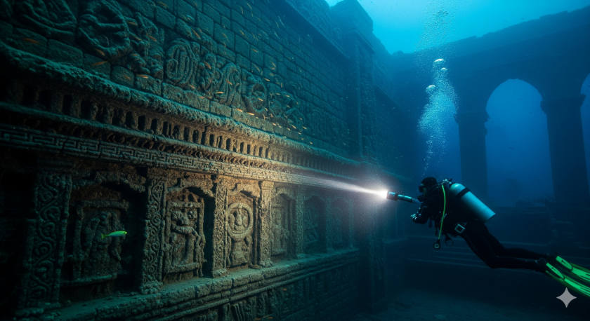
A diver’s torch cuts through the deep blue gloom, thousands of feet from shore. The light sweeps across what should be a sandy seabed or a coral reef. Instead, it catches the edge of a perfectly straight, massive stone wall.
The beam travels upward, revealing blocks cut with impossible precision, stacked in a way that nature never could. Is this just a trick of the light, a bizarre geological fluke? Or is this the edge of a lost world, a chapter of human history that the sea swallowed whole?
For generations, we have been told that civilization began in Mesopotamia and Egypt around 5,000 years ago. But a powerful rumor persists, whispered among rogue archaeologists, deep-sea explorers, and keepers of ancient traditions.
This rumor claims that before the recognized empires rose, other great societies thrived on coastal plains that are now hundreds of feet underwater. These aren’t just myths like Atlantis; they are physical places, hinted at in declassified sonar logs, ancient texts, and legends of a great flood that wiped the Earth clean.
This report is a journey into that submerged world. We will explore the stunning ruins of confirmed underwater cities, examine the most controversial sonar scans that have baffled scientists, and listen to the ancient stories of global cataclysms.
You will see the evidence that has been overlooked, minimized, or perhaps, hidden. By the end, you will have the tools to judge for yourself and even join the search for the civilizations that time forgot.
The Map the Tides Tried to Hide (Global Case Files)
The evidence for a lost, global maritime civilization isn’t in one place. It is a puzzle scattered across the world’s continental shelves. Below is a dossier of the most compelling targets—some are officially recognized archaeological treasures, while others are fiercely debated anomalies that could rewrite history. By placing them side-by-side, a stunning pattern begins to emerge.
| Case File | Location | Earliest Report/Discovery | Method | Key Measurements/Features | Compelling Quote | Evidence Tier |
Thonis-Heracleion |
Egypt | 2000 | Sonar, Diver | 5.4m Hapy statue; 700+ anchors; 125+ wrecks | “A civilization frozen in time.” | Primary |
Pavlopetri |
Greece | 1967 | Diver, Sonar | 5,000 years old; 15+ buildings; streets, tombs | “The oldest known submerged town in the world.” | Primary |
Atlit-Yam |
Israel | 1984 | Diver | 9,000 years old; megalithic circle; stone wells | “The largest and best preserved prehistoric settlement ever found on the sea floor.” | Primary |
Baiae |
Italy | 1940s (aerial photos) | Diver | 177 hectares submerged; villas, nymphaeum, mosaics | “Drunken people staggering in the harbor and music everywhere…” -Seneca | Primary |
Port Royal |
Jamaica | 1692 (sank) | Diver | 33 acres sank; pocket watch frozen at 11:43 AM | “The only sunken city in the New World.” | Primary |
Helike |
Greece | 373 BC (sank); 2001 (found) | Sonar, Drilling | Classical city buried under lagoonal silt | “…the walls of the ancient city were still visible underwater.” -Pausanias | Primary |
Yonaguni Monument |
Japan | 1986 | Diver | 100m x 60m x 25m stepped structure; “turtle rock” | “Very difficult to explain away their origin as being purely natural.” -Masaaki Kimura | Debunked/Contested |
Bimini Road |
Bahamas | 1968 | Diver | 0.8 km long linear feature of limestone blocks | “Expect it in ’68 or ’69 — not so far away.” -Edgar Cayce prediction | Debunked/Contested |
Gulf of Khambhat |
India | 2000 | Sonar, Dredge | 9 km long anomaly; 9,500-year-old wood artifact | “It means that the whole model of the origins of civilization…will have to be remade from scratch.” -Graham Hancock | Debunked/Contested |
Cuban “City” |
Cuba | 2001 | Sonar, ROV | 2 sq km of geometric patterns at 750m depth | “Nature couldn’t have built anything so symmetrical.” -Paul Weinzweig | Single-source/Unverified |
Mahabalipuram |
India | 2002 (NIO); 2004 (tsunami) | Sonar, Diver | Walls, stairs, stone blocks 800m offshore | Eyewitnesses saw a “long, straight row of large rocks emerge from the water” during the tsunami. | Para-primary |
Atlantis |
Legendary | c. 360 BC (Plato) | Textual | Legendary island beyond the Pillars of Hercules | “In a single day and night of misfortune…the island of Atlantis…disappeared into the depths of the sea.” | Legendary Framework |
Confirmed Sunken Cities: The Precedent
These sites prove one undeniable fact: entire cities, rich and complex, can and do sink beneath the waves, their memory fading into myth.
Thonis-Heracleion, once the main port of entry to Egypt, vanished for 1,200 years before its discovery in 2000. Divers found colossal 5-meter statues, hundreds of ships, and gold treasures perfectly preserved in the mud. In Greece,
Pavlopetri is a complete 5,000-year-old Bronze Age town with streets, buildings, and tombs, making it the oldest confirmed submerged city on Earth. Off the coast of Israel, the 9,000-year-old village of
Atlit-Yam features stone-lined wells and a mysterious megalithic circle arranged around a freshwater spring, evidence of a sophisticated society from the dawn of agriculture. These are not isolated fishing villages; they are proof that advanced human life has been reclaimed by the sea for millennia.
Debated Anomalies: The Next Frontier
If cities we knew about from texts could be lost, what about those we never knew existed? Off the coast of Japan lies the Yonaguni Monument, a massive terraced structure 100 meters long with sharp, 90-degree angles, enormous steps, and features that proponents like Dr. Masaaki Kimura identify as carved roads and a stadium. Geologists claim it is an unusual but natural formation, yet Kimura insists its complexity is “very difficult to explain away”.
In the Bahamas, the Bimini Road is a half-mile-long pavement of massive, rectangular limestone blocks. Discovered in 1968, it uncannily matched a prophecy by psychic Edgar Cayce, who predicted remnants of Atlantis would be found there. While geologists argue it is fractured “beachrock,” advocates point to evidence of multiple layers of blocks and wedge stones placed underneath, suggesting it is the foundation of a massive ancient harbor wall.
The Deepest Mysteries
Perhaps the most shocking evidence comes from sonar scans. In 2001, off the western tip of Cuba, a team led by Pauline Zelitsky detected symmetrical, geometric patterns covering 2 square kilometers at a staggering depth of 750 meters.
ROV footage revealed what appeared to be massive pyramid-like and circular structures made of hewn granite. The discovery team leader declared, “Nature couldn’t have built anything so symmetrical”. In the Gulf of Khambhat, India, sonar revealed a 9-kilometer-long anomaly with features of a sprawling city.
Dredged artifacts included a piece of wood carbon-dated to 9,500 years old, thousands of years before any known civilization in the area. For researchers like Graham Hancock, this find suggests “the whole model of the origins of civilization…will have to be remade from scratch”.
Paper Trails and Sonar Logs
The most tantalizing clues to these lost worlds aren’t always buried in silt; some are buried in archives. University expedition notes, old maritime charts, salvage claims, and historical society minutes can hold coordinates and descriptions of anomalies that were never followed up on. The real game-changer, however, has been the slow declassification of military data.
During the Cold War, the U.S. military mapped vast stretches of the world’s oceans for submarine navigation. Programs like CORONA used spy satellites to photograph huge areas of the globe, while naval programs created detailed bathymetric (seafloor) maps.
This data, once highly classified, is a potential treasure trove for archaeologists. If an ancient city lay on the seafloor in a strategic channel, it would have been mapped decades ago and locked away in a secure vault.
This intersection of military secrecy and scientific exploration creates a perfect environment where inconvenient discoveries can be quietly shelved. When Pauline Zelitsky’s team found the Cuban anomaly, they were working with the Cuban government on a survey mission.
The discovery of a potential city, thousands of feet deep and thousands of years old, would have been scientifically and politically explosive. Initial interest from major institutions like National Geographic was high, but then, the story simply died.
Funding for follow-up missions was reportedly canceled, and the site has never been revisited. No active conspiracy is required; the existing veil of “national security,” territorial water disputes, or a simple “lack of funding” can effectively suppress a paradigm-shattering find. The data remains un-investigated, and the anomaly remains a mystery.
Voices Older Than Maps
Long before sonar, humanity had its own way of recording cataclysmic changes to the world map: myth. Nearly every culture on Earth has a story of a Great Flood. In India, a fish warns the sage Manu to build a great boat. In Aztec lore, the god Tlaloc warns the couple Tata and Nena to hollow out a log. The Babylonian Epic of Gilgamesh tells of Utnapishtim, who survives a deluge sent by angry gods.
These are not just stories. They are the echoes of a genuine historical trauma: the end of the last Ice Age. Between 12,000 and 6,000 years ago, melting glaciers caused global sea levels to rise by nearly 400 feet, drowning millions of square miles of coastal land—exactly where human civilization would have been most likely to flourish. The flood myths are the survivors’ tales.
But who were the people who drowned? Indigenous oral traditions from across North America provide a shocking and consistent answer: a race of giants.
- The Paiute of Nevada have detailed accounts of a long war against a tribe of red-haired, cannibalistic giants called the Si-Te-Cah, whom they finally trapped in a cave and exterminated.
(Evidence Tier: Para-primary)
- The Choctaw of the Southeast tell of their ancestors fighting a “race of giants” of “wonderful stature” called the Nahullo when they first arrived in the Mississippi Valley.
(Evidence Tier: Para-primary)
- A Comanche chief in 1857 gave an account of a race of 10-foot-tall white men who had built fortified cities across a vast territory before being destroyed by the Great Spirit.
(Evidence Tier: Para-primary)
- The Osage were described by early European explorers as being of “gigantic” stature, with many men standing well over six feet tall.
(Evidence Tier: Para-primary)
Crucially, these traditions consistently link the giants to the builders of the great earthen mounds found throughout the Ohio and Mississippi river valleys. Early settlers and even Abraham Lincoln reported finding skeletons of enormous size within these mounds.
These river systems were the highways of ancient America, leading directly to the sea. This suggests the mound builders were not an isolated, inland people. They were the remnants of a continent-spanning culture whose major coastal centers were the first to be lost when the ice melted. The flood myths are the memory of their destruction; the giant legends are the memory of who they were.
Geology Check: How Cities Drown
Cities can be swallowed by the sea in several ways. The slow, relentless march of post-glacial sea-level rise submerged Atlit-Yam over thousands of years. More dramatic events like earthquakes can cause the land itself to sink in a process called subsidence, which is what doomed Port Royal. An earthquake can also trigger a tsunami, a massive wave that can overwhelm and bury a coastal city in minutes, as happened to Helike.
Skeptics often argue that the most controversial underwater sites are simply tricks of geology. They point to natural formations that create uncanny geometric patterns. The Giant’s Causeway in Ireland, for example, is formed by columnar basalt, where cooling lava fractures into near-perfect hexagonal columns. They also explain that beachrock , a type of sandstone that forms on shorelines, can break along natural fracture lines to create blocky, rectangular shapes—the primary explanation used to dismiss the Bimini Road.
But nature’s deceptions have limits. To distinguish a natural formation from a lost city, you can use a simple checklist—an engineering signature that is hard to fake:
- Right Angles and Straight Lines: Are there too many, and are they too perfect, to be the result of random fractures?
- Multiple Courses: Are blocks clearly stacked in layers, one on top of another? This is a hallmark of construction.
- Tool Marks: Do the stones show signs of being cut, shaped, or quarried?
- Context: Are there other signs of a settlement nearby, such as pottery, anchors, or other artifacts?
Photos, Sonar, and “Too Square to Be Natural?”
Some images are so powerful they refuse to be dismissed. Here are the most widely circulated visual files that keep the debate raging.
- The Yonaguni Monument, Japan: Discovered in 1986 by diver Kihachiro Aratake, this massive underwater terrace looks for all the world like a sunken pyramid. Wide shots show a vast, 100-meter-long structure with flat terraces and impossibly sharp, 90-degree angles. Close-ups reveal what appear to be enormous, carved steps. Proponents are convinced it is man-made, while geologists insist it is a natural, though unusual, sandstone formation.
(Evidence Tier: Debunked/Contested)
- The Bimini Road, Bahamas: This half-mile-long, perfectly linear feature of massive limestone blocks looks like a colossal ancient highway or pier. Discovered in 1968, it remains one of the most iconic and debated underwater sites. Skeptics claim it is natural beachrock that has fractured in place. Believers, however, point to evidence of a second layer of blocks beneath the first, as well as smaller “prop stones” wedged underneath, as clear signs of construction.
(Evidence Tier: Debunked/Contested)
- The Cuban Sonar Scans: Released in 2001 by Paulina Zelitsky’s exploration company, these grainy sonar images show stunningly geometric patterns on the seafloor 750 meters deep. The images depict pyramids, circular buildings, and a grid-like layout that strongly suggests a city. Because of the extreme depth and the subsequent lack of follow-up, these images remain unverified but are perhaps the most tantalizing evidence of a truly ancient, lost civilization.
(Evidence Tier: Single-source/Unverified)
- The Giant of Castelnau: This 1890 photograph shows three bone fragments—a humerus, tibia, and femoral mid-shaft—discovered in a Bronze Age cemetery in France. Next to a normal human arm bone, their scale is immense. The discoverer, Georges Vacher de Lapouge, estimated the individual would have stood between 10 and 11 feet tall. While mainstream science dismisses such finds as misidentified animal bones, the photographic evidence from the 19th century is compelling.
(Evidence Tier: Debunked/Contested)
- The “Worth1000” Giant Skeleton: This famous image shows a massive human skeleton being excavated by an archaeologist. It has circulated online for years as proof of giants. However, this image is a confirmed fake, created in 2002 for a digital art competition on the website Worth1000.com.
(Evidence Tier: Debunked/Contested)
The well-publicized debunking of modern, photoshopped images like the Worth1000 skeleton serves a convenient purpose for skeptics. It allows them to dismiss all evidence of giants by association. By showing a clear fake, they imply that the entire topic is a hoax.
This is a classic red herring. It deliberately ignores the hundreds of pre-Photoshop accounts from the 19th and early 20th centuries—detailed reports in reputable newspapers and even Smithsonian field journals—of giant skeletons being unearthed.
The existence of a modern digital fake does not invalidate a historical account; it only distracts from the real mystery: what happened to all the physical bones that were reportedly discovered and sent to museums?
The Underwater Suppression Theory
The pattern of dismissal is not limited to underwater sites. For over a century, local newspapers across America reported the discovery of enormous skeletons, often in ancient earthen mounds. A stunning number of these reports end the same way: the bones were sent to the Smithsonian Institution, after which they were never seen or heard from again.
- In 1883, a Smithsonian team excavating a mound in Charleston, West Virginia, found a skeleton measuring 7 feet, 6 inches tall inside a burial vault, along with numerous copper artifacts. The find was documented in the Bureau of Ethnology’s own annual report.
- In the 1920s, excavations on Catalina Island, California , uncovered a burial complex with over 4,000 skeletons, including kings reportedly over 9 feet tall. The field reports and photographs were sent to the Smithsonian.
Today, the Smithsonian denies having any giant skeletons in its collection. Officials attribute the historical accounts to hoaxes, misidentification of animal bones, or the exaggerations of “amateur anthropologists”. Dr. Aleš Hrdlička, a former curator, famously blamed the reports on the public’s “will to believe”. Yet the sheer volume of detailed, independent reports from reputable sources, including the Smithsonian’s own agents, suggests something more than simple mistakes.
This historical pattern of evidence vanishing into institutional archives provides a chilling context for the mysteries of the deep. A “suppression theory” does not require a shadowy conspiracy. Modern bureaucracy and legal frameworks can achieve the same result.
Access to underwater sites is tightly controlled by government permits, which are rarely granted for controversial locations. Vast areas of the ocean are designated as military ranges, placing them off-limits to civilian research. And artifacts recovered can disappear into museum storerooms, uncatalogued and inaccessible for decades. The result is a system that effectively filters out evidence that challenges the established timeline of history.
Anatomy of a “Lost Port”
To identify a potential submerged settlement, it helps to know what to look for. Ancient coastal cities, especially major ports in the Mediterranean, shared common architectural features designed for trade and defense.
- Breakwaters & Moles: The most obvious features are massive stone walls built out into the sea to create a calm, protected harbor. These could be hundreds of meters long.
- Quays & Piers: These are paved, dock-like structures along the inner harbor where ships would moor to load and unload cargo.
- Ship-Sheds: Long, covered structures, often built on ramps, used to house and repair military vessels.
- Warehouses & Colonnades: Large buildings near the quays were essential for storing goods like grain, wine, and olive oil.
- Canals & Drains: Sophisticated ports often had engineered channels to connect different basins or flush out silt.
- Amphora Scatters: A tell-tale sign of ancient trade is a dense field of broken pottery, especially the large jars known as amphorae used to transport goods.
When we view the Bimini Road or the Yonaguni Monument through this lens, the features take on new meaning. The long, linear structure at Bimini is perfectly suited to be a breakwater. The flat, terraced areas at Yonaguni could easily be quays or temple platforms. The presence of these specific architectural patterns makes a purely natural origin much harder to defend.
Field Guide: How Readers Can Investigate
The search for our lost history is not limited to academics with million-dollar budgets. With modern digital tools, anyone can become a citizen-sleuth and contribute to the investigation.
- Step 1: Scan Newspaper Archives: The Library of Congress’s Chronicling America project has digitized millions of newspaper pages from 1770 to 1963. Use the advanced search to look for phrases like “giant skeleton,” “underwater ruins,” or the names of local coastal towns in your state. You may uncover a forgotten discovery in your own backyard.
- Step 2: Check Hydrographic Offices: National Oceanic and Atmospheric Administration (NOAA) makes a vast amount of its bathymetric data public. Use their online data viewers to scan the seafloor off your local coast for strange, geometric anomalies that might warrant a closer look.
- Step 3: Access University Archives: University libraries often have digital archives of master’s theses and doctoral dissertations. A student’s paper on local geology or coastal history from decades ago might contain a crucial map or an overlooked reference.
- Step 4: Contact Local Experts: Your local historical society, maritime museum, or dive club is a fantastic resource. Their members often have deep knowledge of local legends, shipwrecks, and strange underwater finds that never made the official record.
- Step 5: File a Public Records Request: The Freedom of Information Act (FOIA) gives you the right to request records from federal agencies. If you find a reference to a specific expedition or a survey in a restricted area, you can file a request for the records.
Here is a simple, respectful email template for requesting information from a museum or historical society, based on professional guidelines :
Subject: Inquiry Regarding
Dear [Curator’s Name or “Curator of Collections”],
My name is, and I am a [research occupation] from [location]
I am conducting personal research into the maritime history of our region and came across a reference to [subject matter]. I am writing to respectfully request any summary information or catalog entries you may have on this subject.
Specifically, I am interested in learning more about [subject of research].
Thank you for your time and for your work in preserving our local history. Any information you could provide would be greatly appreciated.
Sincerely,
[First and Last Name]
[email_address@domain.com]
[Optional Phone Number]
FAQ
- How old could these cities really be?
The evidence points to an incredible antiquity. The confirmed site of Atlit-Yam in Israel is 9,000 years old. The wood artifact dredged from the Gulf of Khambhat site in India was dated to 9,500 years old. This pushes the timeline for organized, settled civilization back to the very end of the last Ice Age, thousands of years before Sumer or Egypt.
(Evidence Tier: Primary for Atlit-Yam, Debunked/Contested for Khambhat).
- Why are there so many rectangles and straight lines?
Skeptics argue that natural geological processes like columnar jointing in basalt and the fracturing of beachrock can create straight lines and right angles. However, proponents argue that the sheer concentration, complexity, and organization of these features at sites like Yonaguni and the Cuban anomaly defy a natural explanation. Nature produces occasional geometric forms; engineering produces organized systems of them.
(Evidence Tier: Debunked/Contested).
- If this is real, why the official silence?
There is no single reason, but a combination of factors creates a “de facto” silence. Scientific paradigms are incredibly resistant to change. Deep-sea archaeology is prohibitively expensive. And many of the most promising areas are under military jurisdiction or in politically sensitive waters, making access for independent researchers nearly impossible. - Couldn’t storm debris just look like a ruined city?
A powerful tsunami or hurricane can certainly leave a jumble of rocks and debris on the seafloor. However, a storm cannot create a grid of streets, stack multi-ton blocks into layered walls, or carve symmetrical megaliths. The difference is between random chaos and intelligent order.
(Evidence Tier: Primary for confirmed sites).
Final Thought
The oceans cover 70% of our planet, and we have mapped less than a quarter of the seafloor in high resolution. What we have been taught as our complete history may only be the last few chapters of a much longer, more spectacular story. The evidence presented here is not conclusive proof, but it is a powerful invitation to be curious. It suggests that the myths of a lost world and a great flood may be more than just stories.
The search for these forgotten civilizations is one of the last great adventures on Earth. It is a search that you can be a part of. The next clue might not be in a high-tech submersible, but in a dusty library archive, a faded newspaper clipping, or a story passed down through your own family. Keep your eyes open. Keep asking questions. The truth is out there, waiting to be rediscovered.
We invite you to join the search. If you have old scans, family stories, coordinates of seafloor anomalies, or expedition notes, please share them with us.
Sources We used to Write the Article
- MDPI Water — Coastal adaptation to climate change and sea level rise
- Medium — Book review: Fingerprints of the Gods (Graham Hancock)
- Cleopatra site — Thonis Heracleion sunken port in Egypt
- Ancient Origins — Pavlopetri, 5,000 year old underwater town in Greece
- Ancient Origins — Atlit Yam, a 9,000 year old submerged settlement
- Italy Trails — Guide to the submerged archaeological park of Baia
- CMU DROP Lab — Robotic survey of sunken Port Royal
- Institute of Nautical Archaeology — Port Royal harbor excavation
- Impactful Ninja — Ancient Japanese underwater monument
- Map My Heart Blog — Bimini Island stories and legends
- Jules Verne site — Dwarka and Gulf of Cambay lost city page
- Learning History — Claims of an underwater city in Cuba
- Wikipedia — Cuban underwater formation
- Greeka — Santorini and the Atlantis myth
- Wikipedia — Mu, the mythical lost continent
- The Past — Finding Thonis Heracleion under the sea
- Wikipedia — Helike, the lost Greek city
- Wikipedia — SOSUS undersea surveillance system
- U.S. DoD AARO — All domain Anomaly Resolution Office
- BOEM — Geophysical survey EA, archaeological resources section
- Jerusalem Post — Cuba’s ancient underwater structures
- Big Think — Why flood myths are common worldwide
- Wikipedia — Flood myth overview
- Number Analytics — The science behind sea level rise
- ResearchGate — Atlit Yam SPLASHCOS field school (2011)
- YouTube — Port Royal underwater cities documentary
- Reddit r/AskHistorians — Minoan collapse and volcano tsunami debate
- Radisson Hotels — Discovering Mahabalipuram underwater city
- Archaeology Wiki — Sunken town off Mamallapuram, India
- Wikipedia — Bimini Road
- CiteSeerX — Eugene Shinn on the mystique of beachrock
- Systemagic Motives — Critique of the skeptical record on Bimini Road
- Historic Mysteries — The Yonaguni Monument controversy
- YouTube Short — Graham Hancock on Yonaguni
- Wikipedia — Yonaguni Monument
- Ancient Origins — What happened to the sunken city of Cuba?
- CBS News — Photos of artifacts from Egypt’s sunken city
- Wikipedia — Pavlopetri
- Subaia Diving — Baia underwater park double dive tour
- Subaia Diving — Underwater Archaeological Park of Baia
- Marine Cadastre — U.S. danger zones and restricted areas
- Wikipedia — Johnston Atoll
- U.S. National Park Service — Permits overview
- Florida Department of State — Archaeology research permits
- Wikipedia — Underwater Cultural Heritage Convention
- MarineLink — Salvage and recovery of treasure and artifacts
- ResearchGate — Underwater cultural heritage regime: problems and solutions
- Coconote — The mystery of Cuba’s sunken city
- OpenEdition Journals — Ancient port structures
- Wikipedia — Ancient Egyptian architecture
- Royal Caribbean — Types of Greek architecture (guide)
- Family Tree Magazine — Top sites for state and local historical newspapers
- California Data — National Hydrography Data (NHD and 3DHP)
- USGS — Methods for national assessment of shoreline change
- MSDS Marine — Students, volunteers, and training opportunities
- Wikipedia — Bathymetry
Other Resources of Interest
- UNESCO Silk Roads — Dwarka underwater heritage page
- IFLScience — Yonaguni “Japan’s Atlantis” overview
- Helike Foundation — Search for ancient Helike
- Wikipedia — Lemuria (lost continent)
- Franck Goddio — Thonis Heracleion project
- Zenodo — Thonis Heracleion in context (PDF)
- Angelika Markul — Zone Yonaguni (artwork)
- Wikipedia — Port of Alexandria
- NASA Earth Observatory — Ancient Rome’s port city from space
- Dreamstime — Bimini Road stock images
- Archaeology Data Service — Handling sensitive data
- FOIA.gov — Freedom of Information Act portal
- FOIA.gov — Frequently asked questions
- University of Miami Law — Marine archaeology and the law of the sea (PDF)
- Minnesota Office of the State Archaeologist — Visiting sites and museums
- Wikipedia — Underwater archaeology
- NIScPR — Submergence of temples off Mahabalipuram (PDF)
- Scribd — Cuban underwater formation (archived copy)
- Wikipedia — Khambhat
- Wikipedia — Port Royal
- Wikipedia — Atlit Yam
- Wikipedia — Heracleion (Thonis)
- ARCUS Atlantis — Minoan hypothesis on Thera and Atlantis
- Archaeology Wiki — Helike, the city that vanished
- ZME Science — Greek city swallowed by the sea
- UNESCO — Underwater archaeological trails (guide)
- Wikipedia — Tartarian Empire
- The Ancient Connection — Yonaguni underwater megalithic site
- YouTube — Alleged underwater city near Cuba
- Alamy — Port Royal underwater stock photos
- Jules Verne site — Atlit Yam Neolithic village page
- Wikipedia — Baiae (submerged Roman site)
- Harvard White Levy — Excavations at Atlit Yam
- YouTube — Atlit Yam documentary (Slice Earth)
- Shutterstock — Pavlopetri images
- Pinterest — Pavlopetri underwater town
- Hilti Group — Statues from Thonis Heracleion at GEM
- Indian Defence Review — Sensational article on an underwater city
- Wikipedia — Baltic Sea anomaly
- Robert Schoch — Research highlights on Yonaguni
- History Defined — Bimini Road: geology or Atlantis
- Before The Egyptians — Cuba underwater claims
- Yunnan Exploration — Underwater lost city in Chinese lake
- Systemagic Motives — Archaeological ruins near Bimini
- WatchMojo — What is the Yonaguni Monument
- All That Is Interesting — Bimini Road overview
- World Economic Forum — AI protecting an ancient Greek shipwreck
- Simon and Schuster — Atlantis in the Caribbean (Andrew Collins)
- YouTube — “10,000 year old” underwater city video
- Wikipedia — Naval mine
- YouTube — Secret submarine bases compilation
- Wikipedia — Sonar
- Canadian Wildlife Federation — Eight quotes on why water is life
- Vatican — Laudato si (2015 encyclical)
- NOAA Ocean Exploration — Seafloor mapping explainer
- Heriot Watt Research — Underwater 3D structures as sonar landmarks
- NOAA Ocean Exploration — Uncovering a pirate city (Port Royal)
- YouTube — ROV footage beneath a salmon farm
- NOAA Ocean Service — Remotely operated vehicles video
- YouTube — Deep ocean ROV encounters (2023)
- NOAA OSPO — Sea surface temperature anomaly charts
- U.S. House — Testimony on anomalous phenomena and withheld info (PDF)
- Wikipedia — Pseudoarchaeology
- Wikipedia — Out of place artifact
- UNESCO — Emergency preparedness for underwater cultural heritage
- Goodreads — Lost Cities of North and Central America (Childress)
- Goodreads — Lost Cities and Ancient Mysteries of South America
- Scribd — Childress: Lost Cities of Ancient Lemuria (PDF)
- Goodreads — Gateway to Atlantis (book page)
- Goodreads — Gateway to Atlantis by Andrew Collins
- Google Books — Gateway to Atlantis (preview/info)
- Edgar Cayce A.R.E. — Dr Greg Little profile
- Goodreads — Edgar Cayce’s Atlantis
- AbeBooks — The Ongoing Search for Edgar Cayce’s Atlantis (Bahamas)
- Goodreads — Underworld by Graham Hancock
- Wikipedia — Fingerprints of the Gods
- History — Top theories about Atlantis